
Alps 2021
The glaciers of the northern Alps, a weary cold heart in the centre of Europe
The northern side of the Alps hosts 3500 glaciers covering an area of 1480 km2, which is certainly a small number compared to the total world glaciation. However, these glacial masses are located within Europe and influenced its history, economic and scientific evolution. Thanks also to the abundant iconographic and photographic documentation, glaciological and paleoclimatic studies, the first societies for the study of glaciers were created here (Commission Internationale des Glaciers, 1894), the revolution of methodologies and instruments, which made glaciology a key science at a global environmental level, began here. Recent research shows that glacialism on this side of the Alps is made up of a few glaciers (less than 20) with an area larger than 10 km2 and a large number of glaciers (almost 3000) with an area of less than 0.1 km2. Among the first ones, there is the Aletsch, a large valley glacier with compound basins with an area of 80 km2 and a maximum thickness of almost 800 m, it constitutes an Alpine exception; other “giants” include the Gorner and Morteratsch in Switzerland, the Mer de Glace in France and the Pasterze in Austria. Although their distribution is geopolitically very diverse (49% of the glacial area of the Alps is concentrated in Switzerland), these glaciers show a similar evolution. Using direct surveys and especially remote sensing (including radar images), it can be seen that Alpine glaciers have lost almost 70% of their area since the mid-19th century and that the retreat has become more pronounced in more recent years (almost one metre of average thickness loss per year). Models based on climate scenarios indicate that 90% of their area and volume could be lost by the end of the century with serious impacts on mountain ecosystems and tourism.
Claudio Smiraglia
Articles
Bibliography
ARTICLES
SMIRAGLIA C., FUGAZZA D. & DIOLAIUTI G. (2021) – Continua inarrestabile il regresso dei ghiacciai italiani e alpini. Le evidenze dei recenti catasti. Il Bollettino. Comitato Scientifico Centrale Club Alpino Italiano, 7-22.

Alps 2019-2020
The glaciers of the southern Alps, the “ruins” of a glorious past
Studies on Italian glaciers began at the end of the 19th century with the Glaciological Commission of the Italian Alpine Club (which became the Italian Glaciological Committee in 1913). Purposes and methods follow the international evolution until today, when the glacier seems to be the most evident symptom and the most perceived symbol of the climate crisis. With an area of 325 km2 (18% of the Alpine total), Italian glaciers encompass a minority portion of Alpine glacialism, but present interesting and peculiar aspects. They are distributed with every aspect in all sectors of the chain, from the Ligurian Sea to the Adriatic, with very different sizes and types. They range from the plateau glacier with radial tongues of the Adamello, the largest
(14 km2), to the valley glaciers with compound basins, such as the Forni or the Lys, to the simple valley glaciers, such as the Ventina or the Cedec, to the debris covered glaciers, such as the Miage and the Belvedere, to the cirque glaciers, the most widespread type, such as the Caspoggio, the Castelli or the Marmolada, up to the tiny glacierets of the Julian Alps, such as the Canin. More than a century of research highlights the great regression from the peak of the Little Ice Age (mid-19th century) and shows, also with the use of advanced techniques (satellite and drone photos, energy balances from supraglacial weather stations, geodetic balances with laser scanners), the continuation and acceleration of the negative phase (areal reduction of 200 km2 since 1960). This has led to the fragmentation of many glaciers (such as the Brenva or the Eastern Fellaria, which have separated into two sections, losing their valley tongues), the extinction of hundreds of small glaciers, the increase in debris-covered glaciers, and the formation of numerous glacial contact lakes.
Claudio Smiraglia
Articles
Bibliography
ARTICLES
BELLONI V., FUGAZZA D. & DI RITA M. (2022) – UAV-based glacier monitoring: GNSS kinematic track post-processing and direct georeferencing for accurate reconstructions in challenging environments. The International Archives of the Photogrammetry, Remote Sensing and Spatial Information Sciences, XLIII-B1-2022 XXIV ISPRS Congress, 6–11 June 2022, Nice, France, 367-373, https://doi.org/10.5194/isprs-archives-XLIII-B1-2022-367-2022.
DI RITA M., FUGAZZA D., BELLONI V., DIOLAIUTI G., SCAIONI M. & CRESPI M. (2020) – Glacier volume change monitoring from UAV observations: issues and potentials of state-of-the-art techniques. Remote Sensing and Spatial Information Sciences, 43, 1041-1048, https://doi.org/10.5194/isprs-archives-XLIII-B2-2020-1041-2020.
FUGAZZA D., SENESE A., AZZONI R. S., D’AGATA C., CAT BERRO D., MERCALLI L., VENTURA F., SMIRAGLIA C. & DIOLAIUTI G. A. (2020) – Variations of Lys Glacier (Monte Rosa massif, Italy) from the Little Ice Age to the present from historical and remote sensing data sets. In: Godone D. (ed.) “Glaciers“, IntechOpen, London, http://dx.doi.org/10.5772/intechopen.91202.
GOBBI M., AMBROSINI R., CASAROTTO C., DIOLAIUTI G., FICETOLA G.F., LENCIONI V., SEPPI R., SMIRAGLIA C., TAMPUCCI D., VALLE B. & CACCIANIGA M. (2021) – Vanishing permanent glaciers: climate change is threatening a European Union habitat (Code 8340) and its poorly known biodiversity. Biodiversity and Conservation, https://doi.org/10.1007/s10531-021-02185-9.
IOLI F., BIANCHI A. , CINA A., DE MICHELE C., MASCHIO P., PASSONI D. & PINTO L. (2022) – Mid-Term Monitoring of Glacier’s Variations with UAVs: The Example of the Belvedere Glacier. Remote Sensing, 14, 28, https:// doi.org/10.3390/rs14010028
PAROLINI M., DE FELICE B., LAMONICA C., CIOCCARELLI S., CROSTA A., DIOLAIUTI G., ORTENZI M.A. & AMBROSINI A. (2021) – Macroplastics contamination on glacier from Italian Central-Western Alps. Environmental Advances, https://doi.org/10.1016/j.envadv.2021.100084.

Himalayas 2018
The “black” glaciers of the third pole, the Himalayas
The Himalayas, together with the Karakorum, have the greatest concentration of glaciers outside the polar ice sheets, so much so that they are called the “Third Pole”. It is not easy to summarise the characteristics and evolution of glacialism in the Himalayas, due to their size (22,800 km2) and climatic complexity. These glaciers, mostly classified as compound basin valley glaciers, are located in a monsoon climate and during the summer are subject to both ablation and accumulation. Only the extensive use of remote sensing with satellite photos repeated over time makes it possible to verify their dynamics. In recent decades, most glaciers have been in recession with regionally diverse negative balances and reductions in thickness rather than length. This has led to an increase in their debris cover (almost all of them are debris-covered glaciers or ‘black glaciers’), which tends to reduce ablation, the formation of supraglacial and glacial contact lakes, a reduction in their flow velocity, and the separation of confluent minor flows. However, thermal insulation by debris is proving to be ineffective due to the formation of thermokarst morphologies (supraglacial lakes, emerging ice cliffs, where ablation is increased). Recent studies conducted on the glaciers, at the foot of the highest peaks (Everest, Kangchenjunga, Cho Oyu), confirmed by satellite analysis and photographic comparisons, show that, both the Nepalese side (Kangchenjunga Glacier) and the Tibetan side (Rongbuk and Gjarag glaciers) are undergoing areal reductions (3-4% losses in the last thirty years) with a slight recent acceleration of the phenomenon. The formation of supraglacial lakes, e.g. on the Rongbuk, is impressive.
Claudio Smiraglia
Reports
Articles
Bibliography
REPORTS
SMIRAGLIA C., DIOLAIUTI G.A., FUGAZZA D., AZZONI R.S., VENTURA F. & BOLLATI A. (2018) – Sulle tracce dei Ghiacciai – Himalaya 2018. Relazione finale, 59 pp.
ARTICLES
BOLLATI A., VENTURA F., SMIRAGLIA C., DIOLAIUTI G., FUGAZZA D. & AZZONI R.S. (2020) – Lo stato dei ghiacciai himalayani: confronti fotografici, rilevamento e telerilevamento per uno studio fra Nepal e Tibet. Geologicamente, 1, 7-15.
SMIRAGLIA C., DIOLAIUTI G., FUGAZZA D., AZZONI R.S., BOLLATI A. & VENTURA F. (2019) – Remote sensing e repeat photography per lo studio dei ghiacciai himalayani: esempi dal Nepal e dalla Cina. Nimbus, 81, 20-37.
Andes 2016
Patagonia’s icefields, the “factory” of icebergs
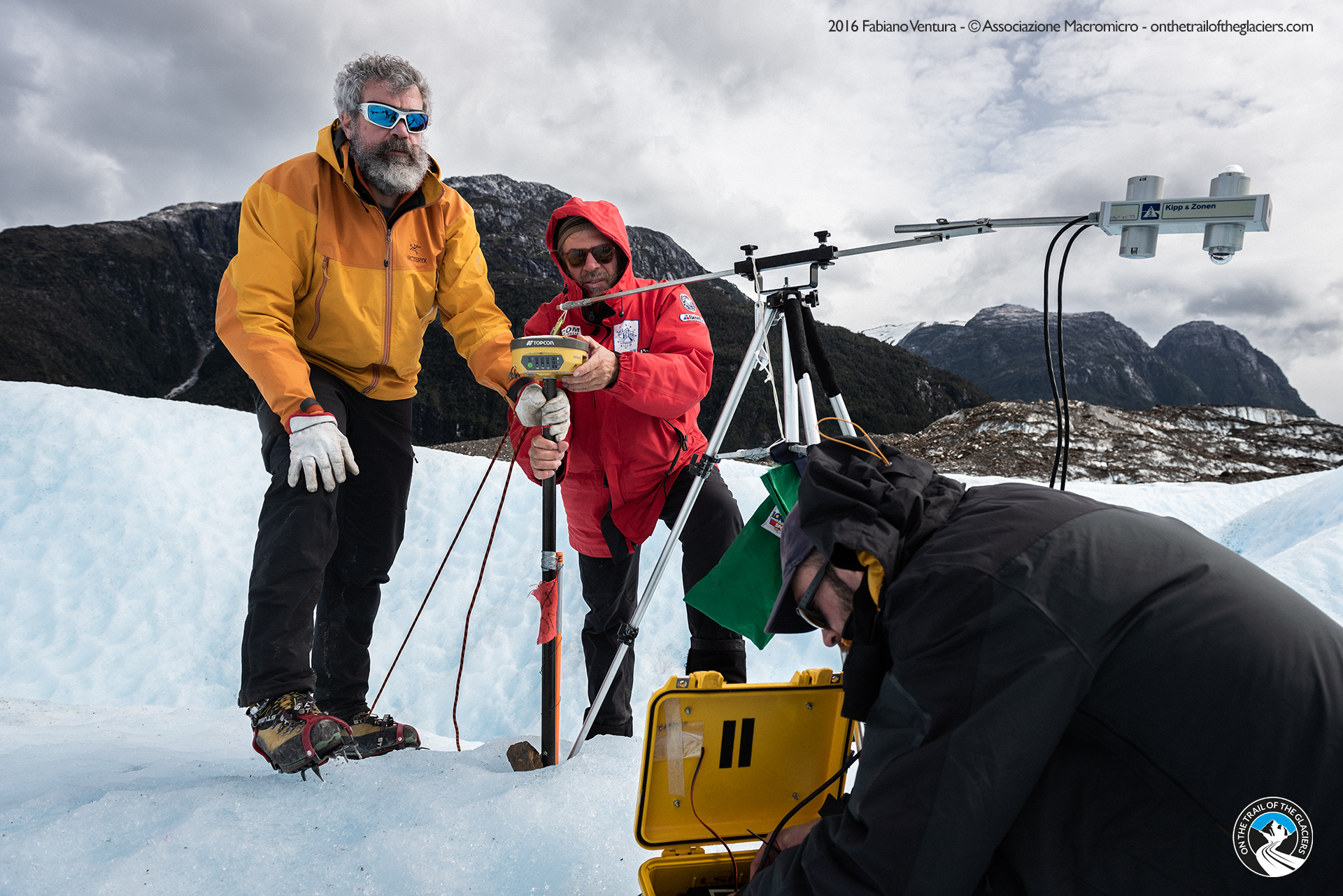
The most impressive glacial masses in South America are concentrated in the two caps of Hielo Patagónico Norte and especially Hielo Patagónico Sur, which is 13,000 km2 wide. These are icefields (caps with a smaller area than the polar ones), from which glacial tongues branch off, entering the Argentine lakes and forming floating platforms; they are the calving glaciers, glaciers that lose mass through the formation of icebergs and not through surface melting. These include the Upsala, the Ameghino and the Perito Moreno; the latter is known for the periodic formation and collapse of an ice dam at its front, which closes off a sector of the lake into which it flows. Recent research based on satellite photo analysis has shown that, despite a similar climatic context, the Ameghino is rapidly retreating (more than 800 m since 1999) and thinning due to melting over much of its area, while the Perito Moreno is stable because its vast upper basin can maintain a positive balance with snow accumulation. Rapid retreat with iceberg detachment and formation of a large lake (more than 60 km2), significant reduction in thickness, separation from tributaries and intense speed acceleration have been observed for the Upsala, which is one of the most dynamic glaciers in the Hielo Patagónico Sur. In recent decades, most of the calving glaciers in the Patagonian icefields have been losing mass at an accelerated rate. Mass loss, although less impressive, has also been observed for many of the non-calving glaciers of Hielo Patagónico Norte. For example, on Exploradores Glacier, located at its northern margin, ground measurements and satellite observations indicate a steady loss of thickness with the formation of large supraglacial and proglacial lakes.
Claudio Smiraglia
Reports
Articles
Bibliography
REPORTS
TAMBURINI A., COMPOSTELLA C., FUGAZZA D. & CACCIANIGA M. (2016) – PATAGONIA 2016. Spedizione Scientifica “Patagonia 2016” al Ghiacciaio Exploradores, Ande Patagoniche, Cile. Relazione Scientifica Progetto “Sulle tracce dei ghiacciai”, 1-8.
ARTICLES
DI TULLIO M., NOCCHI F., CAMPLANI A., EMANUELLI N., NASCETTI A. & CRESPI M. (2018) – Copernicus big data and Google Earth engine for glacier surface velocity field monitoring: feasibility demonstration on San Rafael and San Quintin glaciers. Int. Arch. Photogramm. Remote Sens. Spatial Inf. Sci., XLII-3, 289–294.https://doi.org/10.5194/isprs-archives-XLII-3-289.

Caucasus 2011
The “forbidden” glaciers of the Caucasus between Europe and Asia
After the first nineteenth-century «western» mountaineering-photographic explorations by Freshfield, de Déchy, Mummery and Sella, the glaciers of the Caucasus were hardly accessible to the international scientific community for almost the entire 20th century, being entirely within the Soviet Bloc. This is not to say that their fluctuations have not been extensively studied and monitored by Russian and Georgian glaciologists. The same scientific community, in 2020, inventoried 2223 glaciers covering an area of 1381 km2. Therefore, compared to the Alpine chain, despite the presence of 6 peaks over 5000 m, glacialism is less developed. The more southerly latitude and higher average summer temperatures are the main reason for this. Over the last 20 years, the glaciers in the Caucasus have shrunk by 23% in terms of surface area, a figure very similar to that observed in the Alps and one of the largest in the world. In addition to rising summer temperatures, an unprecedented series of Saharan dust depositions, reducing the reflectivity of snow and ice (albedo), has contributed to the accelerated melting of snow and ice. The 2011
expedition of the project «On the Trails of the Glaciers» visited and studied the glaciers of Svanezia, on the Georgian side of the Caucasus. The Tviberi glacier is located in this region and represents the most striking example of Caucasian deglaciation. At the peak of the Little Ice Age (1850), it was the largest glacier in the Caucasus (47.5 km2); the large debris-covered valley tongue fed by several basins made it more similar to Himalayan glaciers than to Alpine ones. In the following decades, climate change caused a 4 km retreat of the valley tongue and the complete fragmentation into 1 2 small glaciers with an overall areal contraction by 35%, among the largest in the entire region.
Riccardo Scotti
Reports
Articles
Bibliography
REPORTS
SCOTTI R. (2011) – Recent length and surface variations of Chaalat, Adish and Tviber glaciers – Enguri river basin, Georgia, Caucasus. On the Trails of Glaciers “Caucasus 2011” – Scientific Results, 36 pp.
ARTICLES
SCOTTI R., HEWITT K., SMIRAGLIA C. & VENTURA F. (2012) – Length and surface variations of Chaalati, Adishi and Tviberi glaciers from LIA to the present (Enguri river basin, Georgia, Caucasus). Abstract. 16th Alpine Glaciology Meeting 2-3 February 2012, ETH Zürich, Switzerland

Karakorum 2009
Between the ‘pulsating’ glaciers and the “anomalies” of the Karakoram
The Karakorum is one of the most interesting glaciological regions on the planet, both in terms of the extent of its glacial coverage (18,000 km2) and its special features. These glaciers feed densely populated river basins such as the Indus and show a very different evolution compared to the glaciers of the various continents. Scientific missions started at the end of the 19th century, including by Italian scholars such as Ardito Desio in the last century, and most recent ones, have highlighted numerous surging glaciers, showing sudden pulsations and accelerations, lasting from a few months to a few years. The Baltoro Glacier, one of the largest (59 km long), is a ‘black glacier’ or debris-covered glacier, with its tongue covered by debris. Recent research based on ground measurements and remote sensing has assessed the energy balance and measured the resulting ablation (thickness reduction of 1 cm per day with 40 cm of debris thickness). Numerous pulsations (surges) were identified among the lateral glaciers, particularly for the Liligo Glacier. Here there is evidence of two rapid advances, the first at the beginning of the 20th century, the second in the 1980s-90s with an advance of 1450 m. Measurements of length variation at the Baltoro front have shown stability, although with reductions in thickness. This is part of an anomalous picture of stability or a slightly positive balance of many glaciers, called the ‘Karakorum Anomaly’. This phenomenon has yet to be investigated and is attributed to both debris cover and local climatic conditions. Recently, the influence of intense irrigation in the arid areas of northwest China has been highlighted, which through evaporation would produce higher humidity and more snowfall.
Claudio Smiraglia
Reports
Articles
Bibliography
REPORTS
D’AQUILA P. (2009) – Resoconto della campagna di misure glaciologiche effettuate nell’area del Baltoro nell’agosto 2009. Progetto Macromicro “Sulle tracce dei ghiacciai”.
ARTICLES
NASCETTI A., NOCCHIA F., CAMPLANI A., DI RICO C. & CRESPI M. (2016) – Exploiting Sentinel-1 amplitude data for glacier surface velocity field measurements: feasibility demonstration on Baltoro glacier. The International Archives of the Photogrammetry, Remote Sensing and Spatial Information Sciences, XLI-B7, XXIII ISPRS Congress, 12–19 July 2016, Prague, 783-788.